|
|
Post by MinnesotaNationalist on Jun 20, 2017 16:59:11 GMT
 Made using a map by atlas-v7x over on Deviantart, which was amazing, and I just had to make a political map of it. I think it's one of my better maps, but a lot (if not most) of that is from atlas-v7x, so thanks for letting me use it! Thanks again to atlas-v7x! edit: as per request by atlas, I changed it so that the topography wasn't showing. |
|
|
|
Post by steve59 on Jun 20, 2017 20:20:20 GMT
MN
Very nice and some interesting political states you invented.
Is there a land link between New Guinea and Australia to the east of the map or possibly still a narrow state? Looks like theres a blue nation tht reaches between the two.
|
|
|
|
Post by MinnesotaNationalist on Jun 20, 2017 20:52:08 GMT
MN Very nice and some interesting political states you invented. Is there a land link between New Guinea and Australia to the east of the map or possibly still a narrow state? Looks like theres a blue nation tht reaches between the two. Indeed New Guinea and Australia are connected, it's just the final connection is just out of frame. |
|
|
|
Post by johnwarrendailey on Jun 25, 2017 15:23:21 GMT
[a href="http://  "]Here's the basic map of Great Lakes Earth[/a] |
|
|
|
Post by steve59 on Jun 25, 2017 19:09:22 GMT
Interesting map. Looks very good. If those changes have been about for a million years or so humanity is going to have a bloody long march from Africa to get to Asia.
I was thiking at first you had disappeared a lot of land but on closer inspection it looks like Indonesia has been pushed into the Indian coastline and most of the ME into NE Africa, plus New Zealand and New Guinea into Australia. Still looks like Greenland and Turkey has gone.
Those lakes will moderate the climate a lot in many areas, especially in Africa, Australia and what was central Asia but is now coastal. Although you could have more problems with maleria for instance with more options for mosquites to breed.
|
|
|
|
Post by MinnesotaNationalist on Jun 26, 2017 14:46:24 GMT
Cross Post: 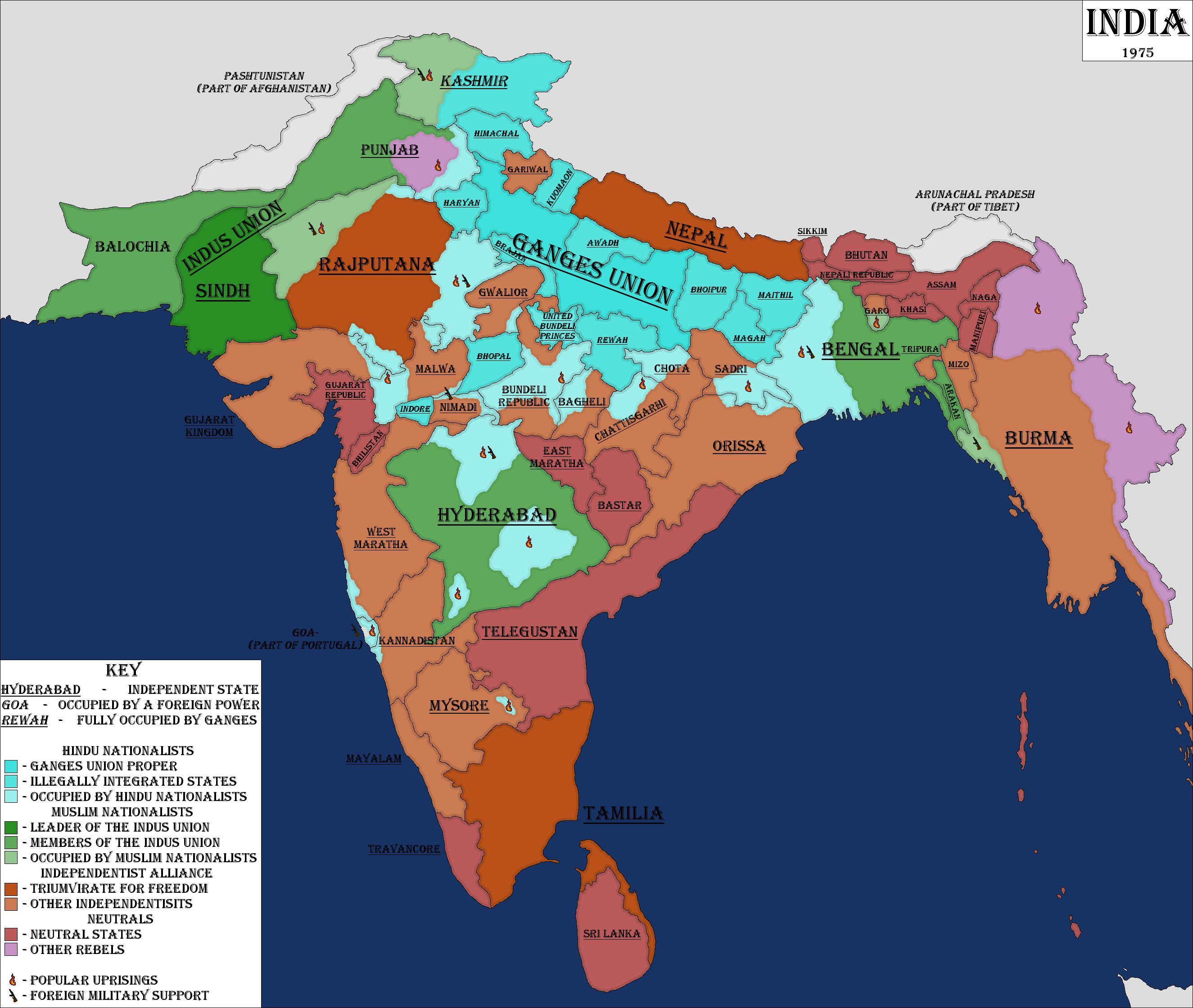 The PoD is that India is divided on nationalist lines, rather than religious lines, along with many of the former Princely States remaining independent (many having to unite together in a German Empire/ UAE like monarchy). This goes very, very poorly as there are many Religious uprisings, the Hindu uprisings supported by the Ganges Union (steadily growing in size as states are annexed into the union), and the Muslim uprisings sponsored by the Indus Union (the IU being more of an alliance than a political union), with both having the ultimate desired result of reuniting most, if not all, of India under either Islam or Hinduism. There's also many rebels who just want to form their own independent state. Both the Ganges Union and the Indus Union bank on states having marginalized religions or nationalities, with Hinduism (or Islam) being the only force unifying them. Opposing both the Ganges Union and the Indus Union are the Independentists, although they're more concerned with the Ganges Union than the Indus Union. To some extent, many members of the Independentists (including 2/3 of the Triumvirate, Nepal and Tamlia) want to carve up the old Princely States into more proper Nation States, but as long as Rajputana has any sort of power, this is not going to happen. The Independentists are supported by the United States, the Ganges Union by the Soviet Union, and the Indus Union by PRChina |
|
|
|
Post by Krall on Jun 27, 2017 0:23:30 GMT
Cross Post: The PoD is that India is divided on nationalist lines, rather than religious lines, along with many of the former Princely States remaining independent (many having to unite together in a German Empire/ UAE like monarchy). This goes very, very poorly as their are many Religious uprisings, the Hindu uprisings supported by the Ganges Union (steadily growing in size as states are annexed into the union), and the Muslim uprisings sponsored by the Indus Union (the IU being more of an alliance than a political union), with both having the ultimate desired result of reuniting most, if not all, of India under either Islam or Hinduism. There's also many rebels who just want to form their own independent state. Both the Ganges Union and the Indus Union bank on states having marginalized religions or nationalities, with Hinduism (or Islam) being the only force unifying them. Opposing both the Ganges Union and the Indus Union are the Independentists, although they're more concerned with the Ganges Union than the Indus Union. To some extent, many members of the Independentists (including 2/3 of the Triumvirate, Nepal and Tamlia) want to carve up the old Princely States into more proper Nation States, but as long as Rajputana has any sort of power, this is not going to happen. The Independentists are supported by the United States, the Ganges Union by the Soviet Union, and the Indus Union by PRChina Very interesting, if somewhat depressing.  At least Afghanistan got the North West Frontier Province - always nice to see them more successful than OTL. |
|
|
|
Post by steve59 on Jun 27, 2017 21:08:47 GMT
MN
Just noticed that part of OTL India is marked as owner by Tibet. Does than mean it escapes Chinese rule in TTL?
Also I'm a bit puzzled that Nepal is included as it was never part of British India?
Steve
|
|
|
|
Post by MinnesotaNationalist on Jun 28, 2017 11:32:28 GMT
MN Just noticed that part of OTL India is marked as owner by Tibet. Does than mean it escapes Chinese rule in TTL? Also I'm a bit puzzled that Nepal is included as it was never part of British India? Steve The Tibet thing is more than likely bad planning on my part, but that part of India is claimed by China through Tibet, so I think that it works. Nepal is included because I wanted to have the entire subcontinent in this mess. Also because I want to. |
|
|
|
Post by johnwarrendailey on Jun 29, 2017 15:07:10 GMT
Interesting map. Looks very good. If those changes have been about for a million years or so humanity is going to have a bloody long march from Africa to get to Asia. I was thiking at first you had disappeared a lot of land but on closer inspection it looks like Indonesia has been pushed into the Indian coastline and most of the ME into NE Africa, plus New Zealand and New Guinea into Australia. Still looks like Greenland and Turkey has gone. Those lakes will moderate the climate a lot in many areas, especially in Africa, Australia and what was central Asia but is now coastal. Although you could have more problems with maleria for instance with more options for mosquites to breed. Greenland is still here. You just have to know where to look. And I never said Great Lakes Earth has mosquitoes...or malaria. |
|
|
|
Post by steve59 on Jun 29, 2017 21:05:20 GMT
Interesting map. Looks very good. If those changes have been about for a million years or so humanity is going to have a bloody long march from Africa to get to Asia. I was thiking at first you had disappeared a lot of land but on closer inspection it looks like Indonesia has been pushed into the Indian coastline and most of the ME into NE Africa, plus New Zealand and New Guinea into Australia. Still looks like Greenland and Turkey has gone. Those lakes will moderate the climate a lot in many areas, especially in Africa, Australia and what was central Asia but is now coastal. Although you could have more problems with maleria for instance with more options for mosquites to breed. Greenland is still here. You just have to know where to look. And I never said Great Lakes Earth has mosquitoes...or malaria. Well the only thing I can see is that I notice there seems to be an arctic continent which with mecantor projection could be it? True this Earth may not have them but without continued ASB intervention something like them is likely to develop. Given nature's famous attitude to vacuums.  Anyway thanks for the map and replies. PS Been trying to work out what's added to Iceland then noticed Newfoundland isn't in its usual place. Is that it? [Eyes aren't what they used to be.  ] |
|
|
|
Post by johnwarrendailey on Jun 29, 2017 23:11:41 GMT
Greenland is still here. You just have to know where to look. And I never said Great Lakes Earth has mosquitoes...or malaria. Well the only thing I can see is that I notice there seems to be an arctic continent which with mecantor projection could be it? No, Greenland is so far to the north that Mont Forel is at latitude 90 degrees--the North Pole. |
|
|
|
Post by Milites on Jul 12, 2017 22:10:08 GMT
My contribution for the MotF over at AH. 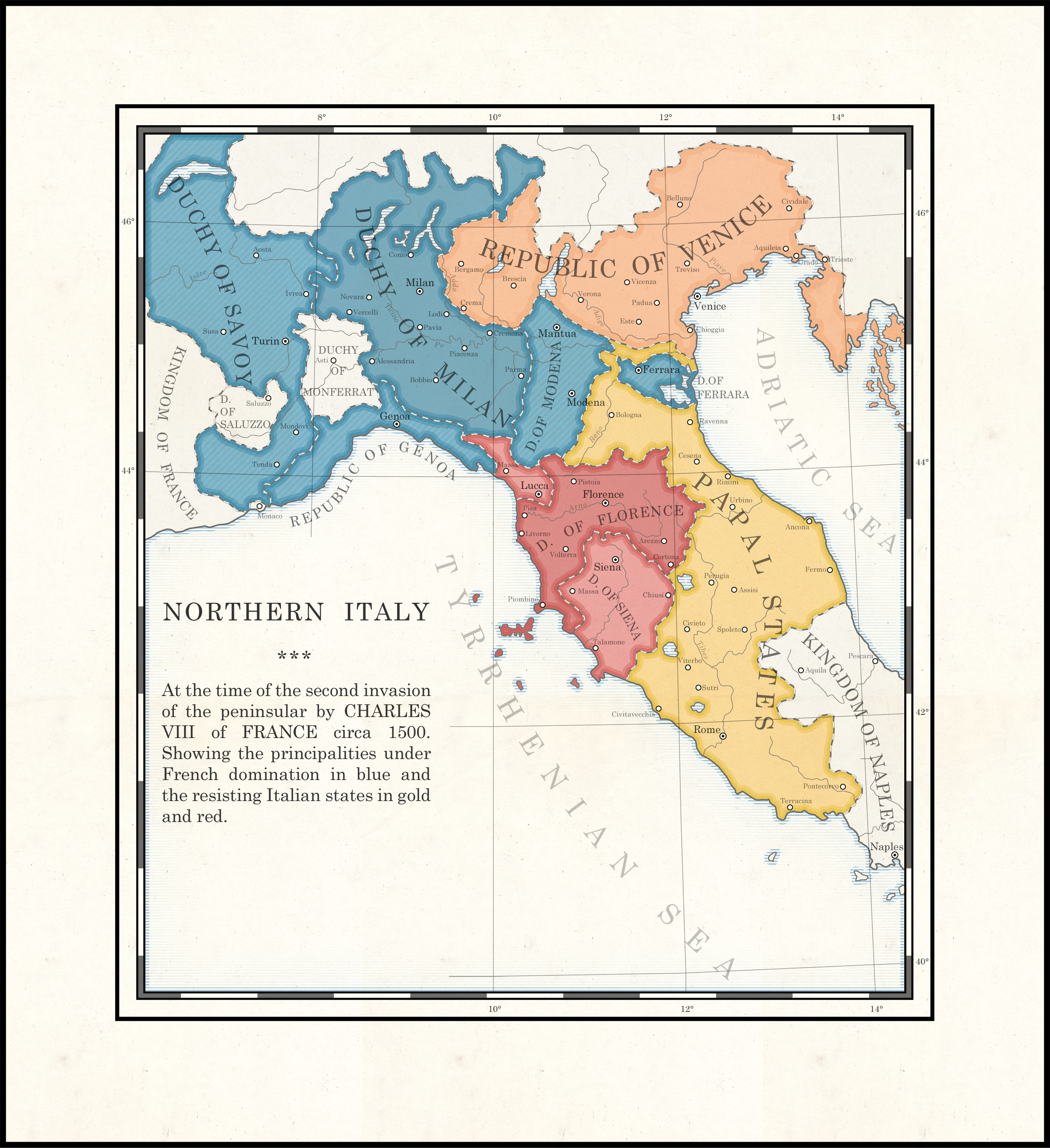 At the Battle of Fornovo, king Charles VIII of France manages to defeat the forces of the Italian League albeit the victory comes at a heavy cost. Leaving his cousin Louis of Orleans behind as duke of Milan, Charles returns to France to regroup and rearm his battered forces in Provence - thus avoiding striking his head on a lintel in Amboise. Meanwhile in Florence, Girolamo Savonarola crushes all domestic political opposition prompting Pope Alexander VI to authorise his son Cesare Borgia to march into Florentine territory and enforce the papal interdict of the messianic friar. Doing so with ease, Borgia is proclaimed duke of Florence by his troops and the Guelph nobles and citizens. Two years later, Charles returns to Italy to defend his dynasty's right to the throne of Milan, occupying the Duchy of Savoy on his march into the peninsular. This second invasion leads Cesare and Alexander to force the republics of Siena and Lucca into subservience of Borgian Florence in opposition of the French intervention. The Venetian Republic also rallies to the side of anti-French coalition. As Charles marshalls his forces in Milan, Ercole I d'Este, known as The Diamond, duke of Modena and Ferrara marries his son Alfonso to a French princess partly to ingratiate himself with the French behemoth to the North and partly in reaction to the execution of Savonarola by the Florentine authorities. In return for his loyalty Louis of Orleans sweeps down south and aids Ercole in conquering the Duchy of Mantua. Although technically still an independent prince styling himself divus, The Diamond has in effect become a French satrap. The states of Northern Italy are thus posed for another round of brutal warfare between those subservient to the King of France led by the Duke of Milan, Louis of Orleans, and those under the Papal aegis of Cesare Borgia. However, events are still in flux. The Emperor has not yet responded, the matter of the Neapolitan throne is still disputed and who's to say that Louis of Orleans will continue to do his cousin's bidding? Thoughts on the scenario? |
|
TheAven
New Member
 Exhausted. That is all.
Posts: 27 
|
Post by TheAven on Jul 15, 2017 22:48:57 GMT
A quick project as some people on dA were complaining that I wasn't producing enough maps As is traditional with my maps, there's no real backstory but rather it's an overview of a hypothetical modern, peaceful Libya. There was no coup and the monarchy managed to fully establish itself. Through close cooperation with the West and Europe, Libya has become a strong exporter of oil and gas but is also trying to diversify their economy. Much like Tunisia in our timeline, Libya is a strong partner of the EU, establishing an association agreements and strong trade ties, it is regarded as an example for other north African states. Internally the state is relatively secular and semi-federal, granting autonomy to the three provinces and various ethnic minorities. This, in combination with the fact that the capital was not transferred to Bayda, as was originally planned, helps to decrease tensions and feelings of Cyrenaican superiority. On dA: fav.me/dbgg2lp |
|
|
|
Post by Krall on Jul 16, 2017 1:16:06 GMT
A quick project as some people on dA were complaining that I wasn't producing enough maps As is traditional with my maps, there's no real backstory but rather it's an overview of a hypothetical modern, peaceful Libya. There was no coup and the monarchy managed to fully establish itself. Through close cooperation with the West and Europe, Libya has become a strong exporter of oil and gas but is also trying to diversify their economy. Much like Tunisia in our timeline, Libya is a strong partner of the EU, establishing an association agreements and strong trade ties, it is regarded as an example for other north African states. Internally the state is relatively secular and semi-federal, granting autonomy to the three provinces and various ethnic minorities. This, in combination with the fact that the capital was not transferred to Bayda, as was originally planned, helps to decrease tensions and feelings of Cyrenaican superiority. On dA: fav.me/dbgg2lpI saw this on your deviantArt and I love how it looks! I do wish there was some more history behind it, though. |
|
TheAven
New Member
Exhausted. That is all.
Posts: 27
|
Post by TheAven on Jul 16, 2017 2:11:46 GMT
A quick project as some people on dA were complaining that I wasn't producing enough maps As is traditional with my maps, there's no real backstory but rather it's an overview of a hypothetical modern, peaceful Libya. There was no coup and the monarchy managed to fully establish itself. Through close cooperation with the West and Europe, Libya has become a strong exporter of oil and gas but is also trying to diversify their economy. Much like Tunisia in our timeline, Libya is a strong partner of the EU, establishing an association agreements and strong trade ties, it is regarded as an example for other north African states. Internally the state is relatively secular and semi-federal, granting autonomy to the three provinces and various ethnic minorities. This, in combination with the fact that the capital was not transferred to Bayda, as was originally planned, helps to decrease tensions and feelings of Cyrenaican superiority. On dA: fav.me/dbgg2lpI saw this on your deviantArt and I love how it looks! I do wish there was some more history behind it, though. Thanks, I'm glad you like it ^_^ And that's not how I work XD Maximum realism and history isn't really important to me. I enjoy working with ideas and concepts. My favourite scenarios expand on things that almost happened or that were proposed. In this case, it's even less about historical accuracy since, as I mentioned, it was just a quick project to distract myself from my work XD |
|
|
|
Post by zalezsky on Jul 17, 2017 15:15:55 GMT
Portugal & The Reconquista I did a ton of research for this map. Unfortunately most of the sources for "conquered areas" comes from accounts such as: "consisting largely of mountains, moorland and forests, were bounded on the north by the Minho River, and on the south by the Mondego River". So there was a slight amount of guess work to be done especially when it came to conquests of cities; where the city limit was quite vague during the 10-12th centuries. It was extremely interesting to read about Portuguese history and the political situations leading to the modern borders of Portugal. For instance "Portugal was obliged to surrender as his ransom almost all the conquests Afonso Henriques had made in Galicia (north of the Minho River) in the previous years." And that's why the northern border of Portugal looks so strange... because it was a ransom. The city of Olivenza is still contested to this day due to a treaty from the 1800's that was drafted during the Napoleonic wars but repealed following the defeat of Napoleon. Sancho I conquered all the way to Silves, only to lose all of the lands south of the Tejo river due to in-fighting with other Christian kingdoms most notably Leon-Castile which had forged an alliance with the Almohads; to combat Portuguese expansionism in Iberia. Link to dA Version: fav.me/dbg401g Notes: I was interested in trying to differentiate my style with regards to pages being visible in the end product. The original concept was supposed to have all the border progressions on the topographic map but it was too clustered and nearly impossible to implement. Thanks to Deatox, ToixStory, and SoaringAven for tips with the creation of this map. A Special thanks to Angelo my Portuguese friend who helped me with finding facts and other details about Portugal If you would like to download or view the full sized version (5k x 4k) consider becoming a Patreon all of my full sized and original files are on there for donators + more perks! |
|
|
|
Post by MinnesotaNationalist on Jul 27, 2017 3:54:07 GMT
Recently came up with an idea of a fantasy water world where islands float and move around. The reason for this is fantasy stuff, like each island (that's not an Iceberg) has a "heart" that slowly replenishes an island of lost resources (because many resources end up being lost into the ocean). 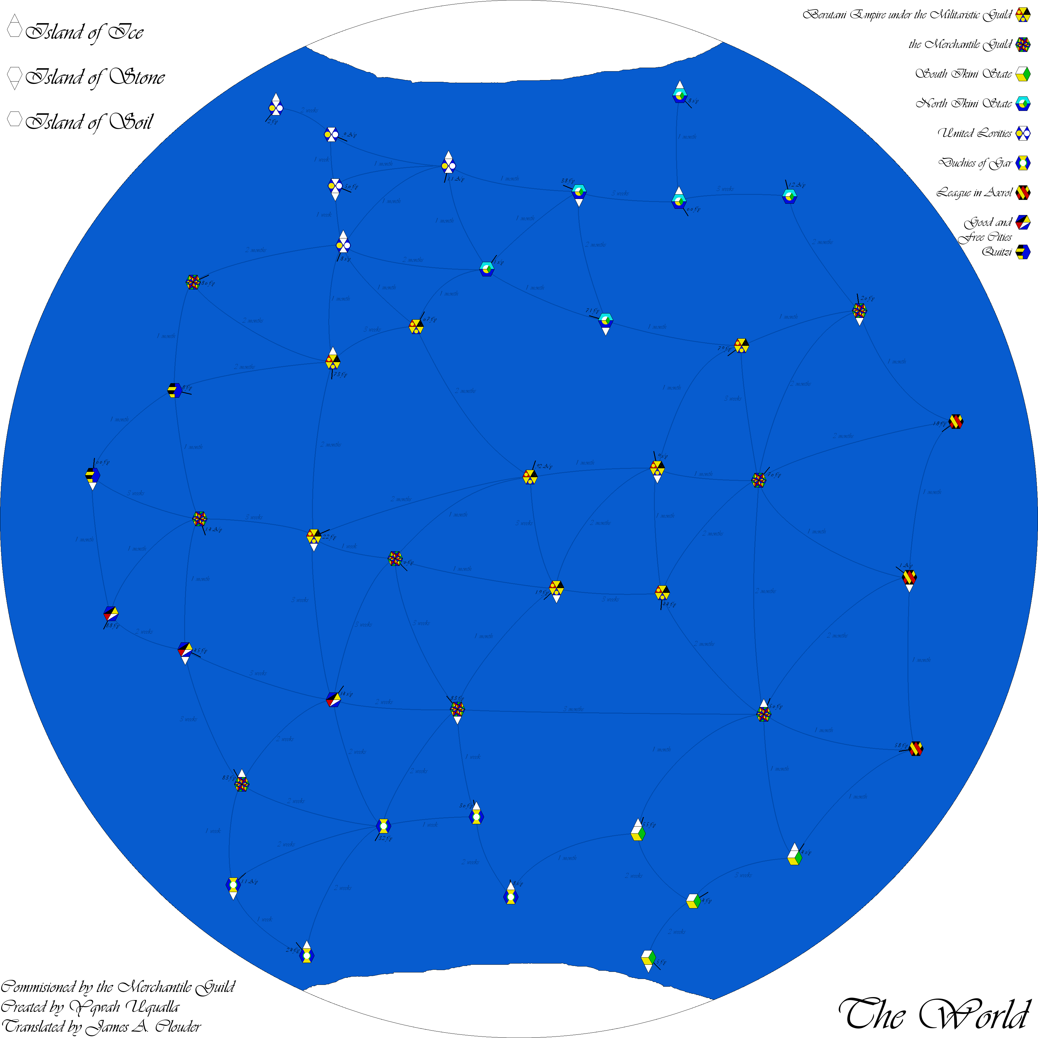 Note on the travel times between islands: One may notice that at some points, it looks like it's faster to go from island A, stop at island B, than go on to island C, rather than go straight from A to C (example: At one point, it takes 3 weeks to go from one island to another, and another month to from the second island to a third, while going from the first to the third takes 2 months, a week longer). I justify this personally because: A, rounding units; B, some of these regions may be dangerous or have odd currents; and C, this isn't exactly meant to show the exact travel times, but rather how much a captain of a ship should prepare before heading out. Note on number of islands: Realistically, there'd probably be many, many, many more islands than this. But between I being lazy and that this was more of a proof of concept than anything else, we're left to the couple dozen islands shown here. |
|
|
|
Post by Milites on Jul 27, 2017 14:18:28 GMT
Nice!
|
|
iserlohn
New Member
Posts: 43
Pronouns: He/Him/His
|
Post by iserlohn on Aug 1, 2017 19:54:08 GMT
To celebrate the announcement of Black America for Amazon Prime, I've decided to do a map that's inspired by the show's premise of a harsh reconstruction and the creation of a freedman homeland in the Deep South. It should be noted that I've decided against including all of Louisiana in New Colonia (as the show's premise suggests) and instead chose to only add portions of Florida and Louisiana to the main territory of Alabama and Mississippi. Enjoy! EDIT: I just noticed that the image scaled up wrong, so I'm gonna redo it. Sorry. I'll insert the new map in about an hour, so this is a placeholder right now.EDIT2: Here's the map, finally! 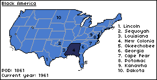 |
|


 ]
]


