|
|
Post by ToixStory on Jan 13, 2016 9:29:49 GMT
Aaaaand now my first map post for the site: "Although often overshadowed by other revolutionary groups during the 21st and 22nd century, the impact of the True Patriots on American history should not be understated. Their impact was twofold. Firstly, they laid the foundation for future Deep Green sympathies and solidarity movements in the continental US, sympathies which would themselves give way to the Magnolia Revolution of 2183 which spelled the end of the Washingtonian USA. Secondly, and more subtly, the True Patriots represent a middle point in the history of Southron Nationalism in America. Where before the True Patriots the main influences on Southron Nationalism were from Confederate Romanticism and White Supremacy after them they were influenced largely by reactions against Neoliberalism and a focus on Agrarianism and Eco-nationalism. The True Patriots themselves represented this middle point in that they contained aspects of both, as evidenced by their flag which still borrowed heavily from Confederate symbolism which was then contrasted by their (especially as the years passed) more colorblind eco-activism."
- Post Script Note written by Professor Nebiyou, Hawassa University, Ethiopia It would figure that the one time Fort Worth gets mentioned, it's because of a massacre. All in all, fantastic map, though! Love the design, love the colors, love the scenario. You really can't do wrong, can you? Also, it seems like the quality of Althistoria's map thread is pretty great these days. Nice to see.  |
|
|
|
Post by espion80 on Jan 14, 2016 0:22:06 GMT
(Crossposting from DeviantArt with Krall's blessing) My personal stab at getting 1919 right. See below for the background. TOTAL BEGINNER HERE. OPEN CALL FOR CONSTRUCTIVE FEEDBACK ON THE MAP, MAPMAKING, FLESHING OUT THE TIMELINE, OR IMPROVING THE ASSUMPTIONS!  A Lasting Peace for Europe, ca. 1935 A Lasting Peace for Europe, ca. 1935
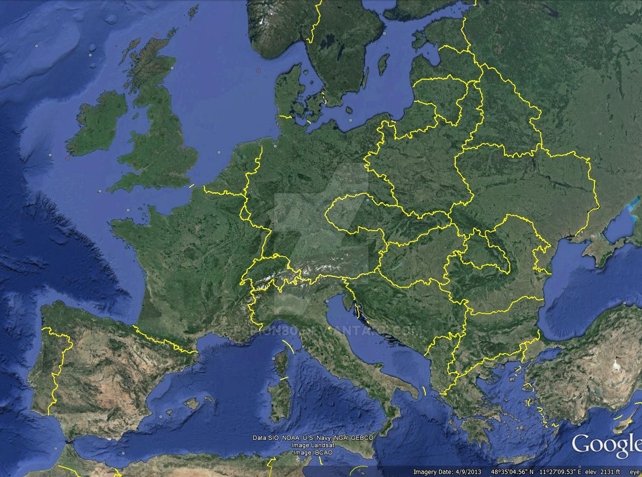 Alternate Versailles 1935 - A Europe Built to Last Alternate Versailles 1935 - A Europe Built to LastCompanion detail maps (so far): Alternate Versailles 1935 - GermanyAlternate Versailles 1935 - CorridorAlternate Versailles 1935 - Defensible Czecholslovakian ConcessionsAlternate Versailles 1935 - PolandAlternate Versailles 1935 - Greater HungaryGOAL A stable postwar European order in which: (i) grounds for German and Hungarian irredentism are minimized; (ii) Germany is better incentivized to pursue constructive policies concerning her neighbors; (iii) national borders are generally defensible; (iv) liberal democracy generally prevails in Central Europe. PROVISIONS(a) Alsace-Lorraine is ceded to France per the original timeline. (b) The Rhineland is demilitarized per the original timeline. (c) The Saarland is placed under probationary French administration pending 1935 reunification referendum per the original timeline. (d) The size of the German military and equipment permitted it is restricted per the original timeline. (e) Total German reparations are reduced to the minimum necessary for physical reconstruction, and a loan mechanism for their fulfillment along the lines of the Young Plan is stipulated. (f) Germany is admitted to League of Nations by 1924. (g) Eupen-Malmedy is ceded to Belgium, but reversible via repurchase after 1930, subject to League approval (2/3 majority member vote). (h) Estonia, Finland, and Latvia gain independence, with all borders matching the original timeline with the exception of those stipulated for Poland (see item p ).
(i) Anti-Bolshevik Allied expeditions in Russia remain concentrated within
the Baltic States, Belarus, and Ukraine, and their presence sustained to
establish of both as Allied client states, replacing Poland as the lynchpin
of the “cordon sanitaire” buffering Europe from Soviet influence or
invasion, and reducing Warsaw’s bargaining power and militarism
accordingly, with a similar effect vis a vis Romania.
(j) The German-Polish frontier is generally drawn with greater care to match
ethnic majorities, provided:
(i) transport is not disrupted;
(ii) the border follows natural courses defined by the local terrain;
(iii) frontiers for Upper Silesia and Masuria are imposed
*without* the bungled plebiscites;
(iv) Bromberg and environs ceded to Poland per the original timeline.
(k) Danzig is placed under probationary Polish administration pending a
1932 reunification referendum, subject to League approval (2/3 majority
member vote), under terms similar to that of the Saarland.
(l) Germany retains portions of prewar Kreise of Putzig and Neustadt
adjoining Danzig’s western border, allowing for restored German territorial
contiguity following a favorable referendum result in Danzig.
(m) Guaranteed Polish sea access retains its original interpretation as
internationalization of the Vistula, and entails:
(i) the waterway and both fortified riverbanks placed under permanent
League of Nations protection;
(ii) at German expense, roads and railways constructed on both
riverbanks, and fortified in turn on each side by “canyon walls” 300
meters in height that descend from the apex of a concrete ramp 500
meters in width with endpoints at Danzig’s southern frontier and the
Vistula Delta;
(iii) one large overhead road and rail structure is permitted to bridge the
fortifications;
(iv) the Bohnsack/Sobieszewo delta island is ceded to Poland for future
port construction.
(n) East Prussia is demilitarized west of the Passarge River.
(o) Pomerania/Weimar West Prussia is demilitarized east of the Wipper River.
(p) Poland’s Eastern frontiers are fully demarcated at the Conference such that:
(i) they follow a refined Curzon-B line that is more ethnically
representative, reasonably defensible, and minimally disruptive of
transport and local economic networks;
(ii) ethnically Polish areas of the northern Kresy, including Wilno, are
similarly incorporated, with Lithuania under Allied pressure to offer no
resistance to Poland;
(iii) they are stabilized by the Allied presence in the new Eastern client
states, including the Baltic States.
(q) An earlier British delegation proposal for Sudetenland is adopted, allowing
for:
(i) smaller yet highly significant areas (e.g. Karlsbad, Reichenberg) to be
awarded to Germany or Austria;
(ii) preservation of a naturally defensible Czechoslovakian frontier.
(r) Austria is guaranteed a reunification referendum no later than 1935,
subject to League approval (2/3 majority member vote), following a secret
Treaty between France, the Netherlands, the UK, and Germany that provides
for:
(i) French annexation of Wallonia by 1930;
(ii) generous German funding for a Flemish separatist campaign resulting
in incorporation into the Netherlands.
(s) Austria retains the German-speaking northernmost third of South Tyrol.
(t) Hungary retains small but important ethnically Hungarian borderlands to the
North, East, and South, without disrupting transport in Slovakia, Romania, or
Yugoslavia.
(u) The Romanian border is drawn with greater care to match ethnic majorities, to
the relative advantage over the original timeline of Ukraine and Bulgaria.
(v) The Ukrainian-Belarusian frontier is drawn along reasonably defensible ethnic
lines.
(w) Russia’s western frontier is drawn by the Allies following highly defensible
geographic features lying between the maximum original timeline advances of
the Whites and the Poles, respectively.
(x) Transylvania, intractably irreconcilable on ethnic grounds to any neighboring
nation-state, is established as a Swiss-style, multi-ethnic state, and is granted:
(i) international tariff exemptions for its exports;
(ii) exemption from controls or taxation by other League members for
incoming foreign investment.
(y) Macedonia is guaranteed a referendum over joining Bulgaria by 1925.
(z) Other minor border corrections are implemented.
Note 1: Balkan conflicts could still occur, but with Russia no longer entangled as in 1914, their impact would not upset the general order.
Note 2: For fun, I'm also assuming a reconciliation of Ulster with Ireland, in exchange for Irish dominion status on the lines of the 1931 Statute of Westminster.
KEY MAP SOURCE MATERIAL LINKS
Aside from the obvious maps covering infrastructure, population density, topography/waterways, etc., here are the ethnic maps which, based on an exhaustive review of alternatives, have proven most useful in terms of both minimal bias and maximum detail:
Poland, Lithuania – Polish Ethnic Distribution, 1918
upload.wikimedia.org/wikipedia/commons/8/82/Bev%C3%B6lkerungsverteilung_Ostmitteleuropa_um_1918.jpg
Silesia – Ethnic Distributions, 1906
gauss.suub.uni-bremen.de/suub/hist/servlet/servlet.hmap?id=245795
East Prussia – Ethnic Distributions, 1906
images31.fotki.com/v1083/photos/1/1272673/5756469/KartederProvinzOstpreussen1900-vi.jpg
Posen – Ethnic Distributions, 1896
freepages.genealogy.rootsweb.ancestry.com/~sobek/maps/posen.gif
West Prussia – Ethnic Distributions, 1910
upload.wikimedia.org/wikipedia/en/thumb/3/37/National_map_of_eastern_provinces_of_German_Reich_based_on_official_census_of_1910.jpg/1280px-National_map_of_eastern_provinces_of_German_Reich_based_on_official_census_of_1910.jpg
Bohemia – German Minority, 1864
commons.wikimedia.org/wiki/File:Sprachenkarte_B%C3%B6hmen.png
Bohemia – German Minority, 1938
s-media-cache-ak0.pinimg.com/originals/a7/70/e3/a770e3b18d6156e3f0c18553d60883ba.jpg
Greater Hungary – Multiethnic Character, 1880
gallica.bnf.fr/ark:/12148/btv1b53023079s/f1.item.zoom
Slovakia – Persistence of Hungarian Minority, 2011
en.wikipedia.org/wiki/Hungarians_in_Slovakia#/media/File:Slovakia_2011_Ethnic.png
Transylvania – Multiethnic Character, 1850
imageshack.com/f/5xerdelyminor92pp5g
Transylvania – Multiethnic Character, 1910
i.imgur.com/ERfpSyQ.jpg
Transylvania – Persistence of Multiethnic Character, 1992 vs 2002
sebok1.adatbank.transindex.ro/terkep/erdely_terkep.jpg
Vojvodina – Persistence of Hungarian Minority and Multiethnic Character, 1880-2002
i.imgur.com/YnTjIur.gif
Belgium – Stable Ethnic Divisions, 1920
upload.wikimedia.org/wikipedia/commons/8/86/Faciliteitengemeenten.png
Ukraine, Ruthenia, Belarus, Bessarabia – Ethnic Distributions, 1900
irbis-nbuv.gov.ua/E_lib/SHOW/00000/00073.jpg
Ukraine, Russia – Maximum Anti-Bolshevik Control, 1919
upload.wikimedia.org/wikipedia/commons/2/2f/Russian_civil_war_in_the_west.svg
Ukraine, Russia – Maximum Polish Control, 1919
upload.wikimedia.org/wikipedia/commons/d/d4/PBW_December_1919.png
SELF-INDULGENT RANT ON RATIONALES AND METHODS SO FAR
As we know, in the original timeline, the Big Three demarcated borders according to a set of considerations that drew only on their own territorial designs, or those advocated by Germany’s least friendly postwar neighbors. The criteria that shaped their guiding considerations were, primarily, a proposal's urgency for advancing each major Allied power’s own national self-interest, and secondarily, the degree to which a given demand could most easily deliver the *perception* of justice, in the sense that populations of concern *to the Allies* had fewer grievances over which to forment economic or even military instability. A military balance of power (in contrast to national self-defense) was the third criterion.
The defeated powers' claims, even the most valid, were of little concern in this process, as the Big Three trusted their own appraisal of what constituted an acceptable outcome for the Reich and its people. Yet fear was widespread both among the rank-and-file Allied delegates at the peace conference - and among each Allied power’s general voting public - that baldly punitive measures might lead Germans to embrace a dangerous, possibly revolutionary mass irredentism. Both George and Wilson, for their own reasons and after their own fashions, felt obliged to acknowledge this risk on multiple occasions. Yet however well-acknowledged the risks of provoking German irredentism, calls to minimize this danger were the least likely demands to ever qualify for inclusion in a Big Three consideration set guiding their final demarcation of Germany’s boundaries. Senior delegates in their charge would often airily dismiss the question as a sentimental over-complication, if not a mark of disloyalty to crown or country. Perversely, one such delegate, having just assisted the Big Three in splitting the Reich’s territory in two to make way for the Polish Corridor, even argued that disregarding the risk of German irredentism was perfectly acceptable *because* Germany’s economic might and vast territory made the nation and its people able to bear such a “minor amputation”. The fruits of such arrogance included, among others, such injured collective pride among tens of millions of educated, civilized German citizens that they were primed, once exhausted by economic depression, to find a certain sweet vengeance in Hitler’s brutal message of hatred and total domination. With that sort of arrogance to answer for, blindsiding the Belgians into partition to buy France’s blessing for an eventual Anschluss could just as well be filed under “humility”.
Apart from Alsace-Lorraine's cession to France, which was sine qua non for France, I have attempted to ground the considerations guiding delineation of these boundaries in extensive pre-1914 documentation of all border regions, covering a range of ethnic, linguistic, and other demographic concentrations (note here that state functionaries dispatched by Berlin to West Prussia, for example, are excluded); transport infrastructure, extractable resources, and heavy industry; as well as natural features such as topography and waterways that provide for boundaries that both better conform to the landscape, and wherever possible, provide natural frontiers.
The borders also reflect my best effort to systematically identify key considerations necessary for the stable division of national territories. To help ensure that these guiding considerations are of any use, I have attempted to compile all territorial demands put forward in 1919, whether by the Allies, by other neighboring states, or by the Germans themselves, and to judge the broader strategic implications of each demand according to three basic criteria. The first criterion is the political urgency of the demand for establishing a stable postwar order firmly rooted in liberal democracy. The second criterion is thematerial benefit of the demand to any affected populations. The third criterion is the military defensibility of the demand's resulting borders, given the local terrain. The extent to which a given demand satisfied these three criteria determined its merit as a guiding consideration. In the admittedly frequent instances where no demand meaningfully satisfied all three criteria, I have attempted to devise a solution that does.
My assumption is that that the consideration sets guiding the revised treaty’s borders here are more advantageous, in that they allow the occasional demand expressed by Germans to qualify as a key consideration when demarcating borders. As such, demands to mitigate the very real risks of German irredentism, obvious enough in 1919, have been able to function as an important consideration when necessary at certain points in the process.
Even so, trade-offs remain between (a) equal, adequate national dignity sufficient to keep a liberal democracy stable; (b) freedom from fear of foreign invasion; and (c) minimal (if to some degree inevitable) disruption to everyday social and economic activity for all Europeans. If (a), (b), and (c) each could be scored from 1 (catastrophe) to 10 (perfection), no practical balance in 1919 could possibly achieve a score of 10 for (a), (b), OR (c) by themselves, let alone in combination. I think the original treaty was something like (a)=4, (b)=7, and (c)=6, giving a "chance for peace" score of 17/30 (57%, an F+ basically)... such a low score for (a) was what allowed fascism to take root in the first place. Were matters settled more rationally and with less bias at the Conference, an IMPROVED (but not perfect) score for (a), at ZERO cost to (b) and in fact ADDING to (c) would have been within easy reach. . I think in 1919, it would have been possible to achieve (a)=8, (b)=7, and (c)=7 - a total "chance for peace" score of 22/30 (73%, still only a C, but at the end of the day, that's enough to pass the test). Following this approach, I suspect that the revised Treaty could have left Europe just less enough inclined to embrace the barbarism of fascist rule to avoid the descent into war.
Consider, for example, just the small Sudetenland awards. Had the Big Three restrained Masaryk's slight overreach with respect to defensible frontiers deep within the Sudetenland, culturally significant German border towns such as Eger, Karlsbad, and Reichenberg, and the PURELY Hungarian swathes of territory in southern Slovakia (Komarno, Dunajska Streda, etc.) could have easily been awarded to Germany and Hungary, respectively. Czechoslovakia's territorial integrity, transport network, and military defensibility would remain intact, the latter merely shifting its basis to mountain ridges slightly closer to Prague. At very little cost, the Germans and the Hungarians would enter the post-Treaty era with an immediate confidence-building sign of goodwill, creating momentum for further constructive policy-making. True, many Germans would remain as minorities in a Czech-dominated state. Insofar as sidestepping the doltschoss effect is key, the borders remain imperfect. However, the perfect has always been the enemy of the good, and that applies equally to perfect "Heim ins Reich" fantasies along the lines of the Henlein map. Raise the individual score for only (a) any higher, or (b) or (c) for that matter, and the other two components lose several points very quickly. *Perfect* ethnic borders, as attempted at Munich in OTL 1938, included thinly populated rural areas well beyond the arguably more important border cities (small benefit), yet they immediately upset the balance of criteria for peaceful coexistence. To my mind, the Sudeten lowlands, and even Pressburg remaining within Czechoslovakia, is a small price to pay to keep the Slovaks in the union, and fortifications intact. This seems especially workable given that meaningful autonomy for Germans within Czechoslovakia was steadily emerging by the 1930s - to the point where people were quite comfortable comparing Czechoslovakia to Switzerland. Henlein and company had little in the way of an audience until Hitler gave people an excuse to indulge more primitive, tribalist fantasies in response to the Depression.
Or, take a look at the revised Corridor solution. Many Germans would still be left under Polish rule, as mostly minorities in Polish towns, or majorities in isolated towns. The only *possible* exception to this, where the documentation, both reasonably objective and forgivably biased, is evenly divided, is the existence of two *barely* contiguous and at best painfully narrow "bridges" of German settlement:
1. possibly eastward from Schneidemühl along the Netze valley through Bromberg and then bending north to Kulm, with an extension stretching to Thorn; and
2. possibly eastward from Neustadt along the Baltic before bending south through Gdingen to Danzig.
The first one, if it existed, contained larger German towns, but simply sat too far inland to allow Poland to defend its sea access, and all infrastructure supporting large-scale transport of goods to the sea ran through Bromberg. Bromberg simply had to become Bydgoszcz for the whole thing to work at all. By contrast, the second one, if it existed, could be the basis for at least a bare minimum of German territorial contiguity, while still leaving Polish sea access workable by way of internationalizing the final couple miles of Vistula and giving the Poles a decent strategic shot at defending that access were hostilities ever to arise. Given coin-toss nature of what appears in the documentation, granting Germany territorial contiguity, though it leaves some Poles within Germany and makes defense of sea access a permanent military concern for Poland, seems a fair exchange if Poland is given the strategic military advantage in the area more generally.
Why, then, the withdrawal of the two referenda most likely in the eyes of the Big Three to favor Poland? After all, a number of Masurians were protestant and loyal to their Junker lords – indeed, such instances weaken the argument for basing territorial divisions on ethnicity at all. Why lower (a)’s score here? My feeling is that the ability of even the most fair-minded of Treaty revisions to reduce irredentism would have come up against its limit in the matter of that special mutual contempt between Germans and Poles. Certainly by all accounts, their circumstances made a shambles of any hope for a free or fair vote. Observers in Masuria reported great fear among Polish tenants of eviction and expropriation by their German landlords if they voted for Poland. In Allenstein, there was Polish harassment of Germans; in Marienwerder, busloads of non-resident Germans pouring in to vote. Meanwhile, in Upper Silesia, the German population was concentrated almost exclusively within isolated "language island" towns, an open invitation for rebellion in the countryside should the town-dwelling side win (exactly what happened). Worse still, the threat of armed violence made voting one's conscience downright dangerous. Poland’s military survival was never far from anyone’s minds, and German newspapers exploited this fear to the point of falsely reporting the fall of Warsaw. In Upper Silesia, as 170,000 Germans rushed in to vote, Kasprzycki's PMO thugs, on orders from by Warsaw, roamed the countryside, attacking anyone who kept his political views to himself, and attracting the equally unwelcome attention of the Freikorps, who had already massacred dozens of Poles in the region in 1919 for daring express Polish identity. To many Poles, what would have been a vote for Poland *suddenly* looked like a vote for homelessness, or life under communist invaders, or submission to thugs like Kasprzycki, and whatever their basic allegiance, they risked being beaten or killed for their choice. In place of active self-determination, then, there remains a place for arbitrary stewardship, with lines based on ethnic distribution drawn and imposed from a distance. Old animosities such as these are the reason that striving for (a)=9 is dangerous.
Still, I'd like to think that the revised treaty does enough to prevent war in general, really. Germany gets enough concessions - both immediately and as rewards for good behavior over time (Danzig and territorial contiguity by 1932 even!) that irredentism would strike most Germans as rather irrational, enough to prevent a Hitler in the first place. So that rather goes a long way to ruling out German aggression.
Meanwhile, with Allied forces in independent Belarus and Ukraine in 1920 per the timeline, Lenin would never have dared to send Stalin and his troops on their march to Warsaw. Stalin would have acquired no thirst for revenge against the Poles and the rest of Europe, and far less experience as a military commander. Meanwhile, no Soviet invasion of Poland means far less prestige and power in the hands of Pilsudski and the other generals, and the survival of liberal democracy in a Poland with every incentive to charm the pants off people in Danzig right up to 1932 (they'd still vote German, just as the Saarland did). Both Soviet and Polish aggression are therefore also unlikely.
|
|
|
|
Post by eDGT on Jan 15, 2016 0:05:59 GMT
Ah, so many lovely maps to compete for space with. Joy of joys. So here's some of the only decent maps I have sitting on my laptop. 1) NEVER!: The world of Operation Doomsday. 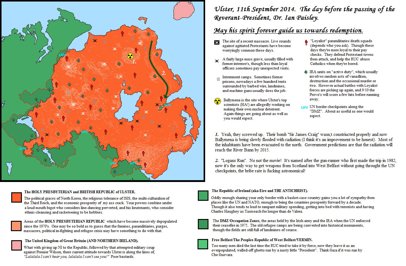 So this was something of a scathing tribute to Reverend Dr. Ian Paisley, made a few days after the news of his death. The POD is that PM Harold Wilson followed through on a hair brained British scheme to declare Northern Ireland independent and pull out during one of the bloodiest periods of the Troubles. IOTL the plan was ditched, obviously, but here it was slightly more carefully planned out. The result was of course still a disaster, just Westminster thought they had all the bases covered. Upon their declaration that NI would be allowed to seek it's own path on February 1973, the Wilsonite Labour government, in conjunction with their Irish opposite numbers, petitioned the United Nations to adopt Northern Ireland as a mandate in order to bring peace to the province. The UUP meanwhile formed an emergency government, which did initially have communications with the SDLP open, but this was quickly cut off. The PIRA upped the armed campaign as soon as the British withdrawal was underway, believing that their bloody tactics had succeeded and that they would soon drive the Planters back into the sea. This was obviously met with a Loyalist response, and the formation of an umbrella organisation for all Loyalist and Unionist paramilitaries: The British Volunteer Army Council. They declared themselves "British" rather than Protestant, Northern Irish, or Ulstermen in a not so subtle attempt to shame the UK. Nearly all of their addresses described the British governments as weak, cowardly, and treacherous. As it turned out the UN Security Council really didn't have any intention of getting involved in Northern Ireland. The American ambassador had been very vague in his responses to British questioning about Ireland, mainly due to Britain's very vague hints at what they were planning. And despite some minor public encouragement to reunify the island the American government was far too distracted with southeast Asia to even think of sending troops to Britain's Vietnam. France offered some words of encouragement whilst quietly snickering about paratroopers, the rest of western Europe peered over to the islands in a morbid curiosity that we might look at a mummified body, it's not every day you get to see a centuries old conflict preserved so well. Tito rolled his eyes upon hearing the news, what sort of civilized European nation has ethnic conflict in this day and age?? The Soviet Union did offer to back Britain's motion, but considering British-Soviet relations at the time that can of worms was best left unopened. Mao Zedong opened his eyes, smiled to himself, and then rolled over back to sleep. Back in Ireland things got much, much worse. The states security forces were at best neutral to the fighting around them, and more often than not openly hostile towards any Catholic who was suspected in having any information, which was of course every Catholic. Refugees from the wrong sort of neighborhoods began to trickle down to the Republic. In October 1973 the Unionist Emergency Government declared themselves "unfit to govern alone", prompting the ascension of more radical elements to Stormont and the throne majestical. A coalition of Loyalism was deemed necessary in the hope that more violent tendencies could be reigned in with a sniff of power, among these forces was the Democratic Unionist Party, and their firebrand Minister leader. ***** 2) Mad Mick: Sequel to Doomsday 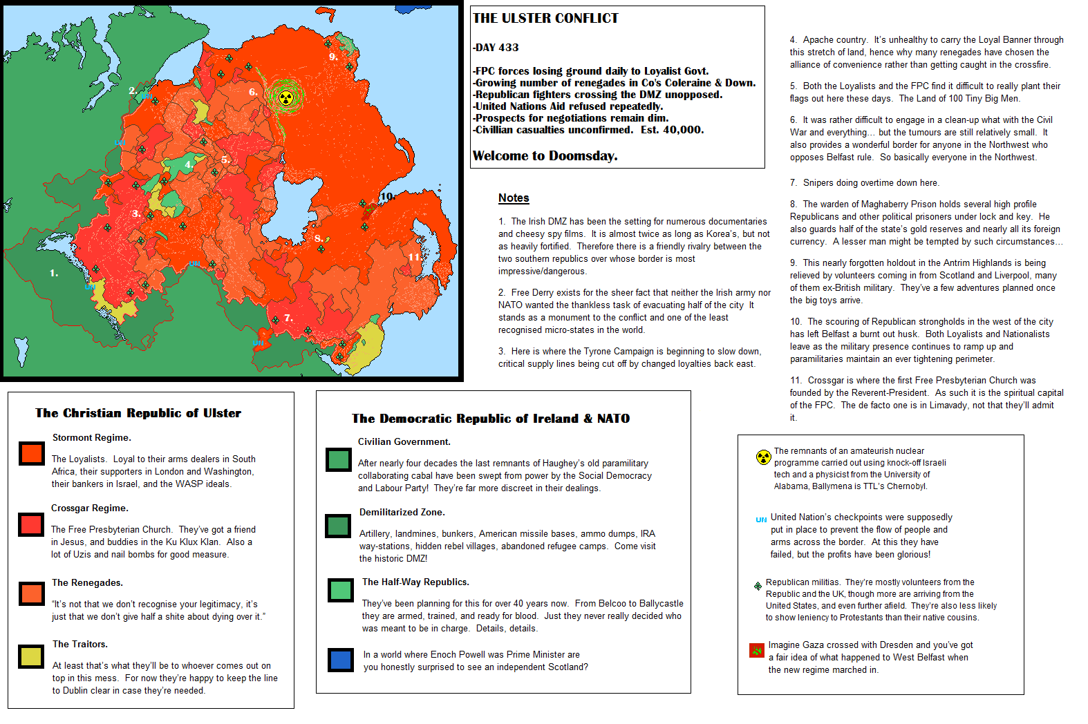 Doomsday's slightly more polished younger brother. Where the original was a tribute to Paisley, it's spiritual successor is a tribute to Peter Robinson's time in office. Oddly enough there was a fear that the Executive was on the verge of collapse at the time I made this. The base map had been slightly edited and improved in between these two. As you can see things did not turn out very well after the Presidents death. Brigadier-General Anthony Snoddy immediately took advantage. The CO of the "Lagan Perimeter"- the artillery blasted area of land which separated the civilian areas of East Belfast from the various Republican strongholds to the north, west, and south; with Belfast City Hall as the bombed out command centre- grabbed a hold of the nations unnecessarily large chemical weapons stockpile and declared his first act as Acting President to be an all out assault on West Belfast in an attempt to catch the Presidents assassins. Snoddy was clearly a few threads short of a sash, and fortunately for the entire world his campaign bogged down within a few days. Supplies and reinforcements were quickly seized and prevented from reaching him as he blasted his way through the dead heart of the city. Snoddy was eventually killed when his armoured car was annihilated by a Republican mortar barrage (the few survivors claim that the strike came from the east, but the camp guards don't listen), but the damage he had done was monumental. West Belfast's "President" had been killed in the fighting, along with many of his lieutenants, and the civilian casualties were beyond calculation. Republican units stationed in the Divis mountains began their own retaliatory campaign against Protestant civilians in the surrounding townlands, and soon enough volunteers from Ireland and Britain were crossing over to join their comrades in the fight to overthrow the Orange menace. With Snoddy out of the picture the former Presidents loyal strong arm was the obvious choice of successor, General John McMichael. His initial moves were sound enough; Special Forces and local militias to be deployed against any active Republican paramilitaries, a massive increase in border strength, soothing noises to be made towards Dublin and London, and a blindfold to be given to anyone brave enough to look in the direction of Belfast. But the funny thing that nobody actually realised, is that when you give the church a modicum of power they get the idea that they should be the ones calling the shots. Of course Paisley had united both the secular and the spiritual with his role, and whilst the Free Presbyterian Church had never been the state religion (as many claimed on internet forums) Paisley's moderators and senior administrators of the church had always played a large part in his running of the state, and they had always inserted a nice fat wedge of Christ into everyone's daily lives. Chief Moderator, John Greer, henceforth decided to take matters into his own hands, by which he of course meant Gods. The good Lord to speak to John, and he did sayeth "The Seed is Strong", and because John had never read A Game of Thrones he didn't get the reference and instead thought that he was being told to plant the Presidents eldest son, Ian Paisley Junior, onto the seat of power. And everything went to shit. |
|
|
|
Post by orvillethird on Jan 15, 2016 0:55:02 GMT
Nice map. I need to do some updating on mine, which is based on an incident from a few years back, which results in some differences in the map of Europe.
|
|
|
|
Post by tardis218 on Jan 16, 2016 22:08:30 GMT
 Sigismund Francis, Archduke of Further Austria does not die in 1665 and goes on to have children. (Along with that the Liechtenstein royal family actually moves to Liechtenstein when the land is bought.) Further Austria is passed down generation to generation, until the son of the heir to the Liechtenstein and the daughter of an Archduke of Further Austria took the Liechtenstein throne, after his father and grandfather died. And a few years later, the Archduke died without children, and the new Prince of Liechtenstein was the closest male relative to the Archduke, and the two lands were united under the helm of Liechtenstein. |
|
|
|
Post by spanishspy on Jan 17, 2016 4:34:45 GMT

Electoral map from my timeline Things That Happen. |
|
|
|
Post by lightninglynx89 on Jan 21, 2016 23:08:53 GMT
Directly taken from Todyo1798 aka edgt on here, this man has a really unique idea and since he hasn't done anymore of these, I guess I'd take a stab at it. So here's mine. Also just like he did, misspelling is intentional.
________________________________________________________________________________________________________
In 525 AD Christian Himyarite, Sumuafa Ashawa, is able to maintain his power in the southern Middle East after being assigned by the King Kaleb. Abreha does not turn his back on Axsum and stays in Axum Yemen to assist in the protection and securing of the region. With Axsum presence in the region, Christianity spreads into the southern Arabian Peninsula. When the Persians came down from their lands to try and conquest in the late 500s, they are repelled due to an established Axum Yemen. When the religion of Ezlahm rose in the 7th century, the wars to spread the religion were met with mixed results. Whilst the Ezlahmic Caliphate rose to unite Arabia, and small parts of the Levant, it never progressed beyond that. Due to being repelled by Axum and Byzantine armies. The Ezlahmic Calpihate fell and collapsed and many splinter sects of the religion came. The more popular Zhunni, the second largest being the Zhiaa, and the smallest being the Ebaji. Good fate continued to shine on Axum as they eventually continued to rise in power and conquered more lands. Later becoming the Axum Empire and a substantial power in the world to this day.
________________________________________________________________________________________________________
When the Kingdom of Italy delcared war on Ethiopia in 1935, they were immediately condemned and acted against by the League of Nations. The League of Nations forces led by the French and British quickly came to the aid of Ethiopia, supplying them with soldiers, vehicles, supplies, and officers. The Kingdom of Italy was quickly defeated in both Europe and Africa, and suffered severe sanctions by the League of Nations, whilst Ethiopia was awarded with part of Italy's old land. When World War II broke out, the Ethiopians quickly snatched up Italy's colonies in Djibouti and Somalia, once again the Ethiopians were awarded these lands after the wars end. When the decolonization of Africa began, many of the independent East African nations quickly fell under Ethiopia's influence due to Ethiopia's track record of being able to stay relevant on the world stage. Ethiopia is currently the head of the East African Trade Union, and a large player in the African Trade Organization. 
|
|
|
|
Post by Krall on Jan 22, 2016 0:30:59 GMT
Directly taken from Todyo1798 aka edgt on here, this man has a really unique idea and since he hasn't done anymore of these, I guess I'd take a stab at it. So here's mine. Also just like he did, misspelling is intentional.
__________________________________________________________________________________________________________________________________
In 525 AD Christian Himyarite, Sumuafa Ashawa, is able to maintain his power in the southern Middle East after being assigned by the King Kaleb. Abreha does not turn his back on Axsum and stays in Axum Yemen to assist in the protection and securing of the region. With Axsum presence in the region, Christianity spreads into the southern Arabian Peninsula. When the Persians came down from their lands to try and conquest in the late 500s, they are repelled due to an established Axum Yemen. When the religion of Ezlahm rose in the 7th century, the wars to spread the religion were met with mixed results. Whilst the Ezlahmic Caliphate rose to unite Arabia, and small parts of the Levant, it never progressed beyond that. Due to being repelled by Axum and Byzantine armies. The Ezlahmic Calpihate fell and collapsed and many splinter sects of the religion came. The more popular Zhunni, the second largest being the Zhiaa, and the smallest being the Ebaji. Good fate continued to shine on Axum as they eventually continued to rise in power and conquered more lands. Later becoming the Axum Empire and a substantial power in the world to this day.
__________________________________________________________________________________________________________________________________
When the Kingdom of Italy delcared war on Ethiopia in 1935, they were immediately condemned and acted against by the League of Nations. The League of Nations forces led by the French and British quickly came to the aid of Ethiopia, supplying them with soldiers, vehicles, supplies, and officers. The Kingdom of Italy was quickly defeated in both Europe and Africa, and suffered severe sanctions by the League of Nations, whilst Ethiopia was awarded with part of Italy's old land. When World War II broke out, the Ethiopians quickly snatched up Italy's colonies in Djibouti and Somalia, once again the Ethiopians were awarded these lands after the wars end. When the decolonization of Africa began, many of the independent East African nations quickly fell under Ethiopia's influence due to Ethiopia's track record of being able to stay relevant on the world stage. Ethiopia is currently the head of the East African Trade Union, and a large player in the African Trade Organization. Nice idea, and nice maps! I like the idea of a surviving Axum, though I'm not sure how plausible Islam rising at the same time and splintering into the same factions despite the different history of the region and of the Caliphate itself is.  It is a really cool idea, though! I might try it myself once I'm done with my MotF map. |
|
iserlohn
New Member

Posts: 43  Pronouns: He/Him/His
|
Post by iserlohn on Jan 22, 2016 21:38:34 GMT
 "The 1980s saw the rise of a new political ideology in the United States: paleoconservatism, or paleocon. After the collapse of the Soviet Union and the apparent signs that America could now, for one thing, rest easy, and secondly that, in retrospect, most American foreign involvements after World War II have been pointless, the paleocon wing of the Republican Party became dominant and ultimately swept into the White House and most state governments in the first half of the 1990s. And with that, America's status of a superpower effectively ended. The America-shaped void in international politics was however quickly filled: the NATO survived, though now "led" by France, and both Japan and Australia, other close American allies, formed their own alliance bloc in order to contain China. Furthermore both China and Russia surged. With recent involvement in Ukraine, Russia is once again a threat to European safety and China has been flexing its naval muscles in the South China Sea has made the Philippines and Japan worried, especially since China has already shown its prowess by annexing the essentially abandoned Taiwan in 2011. Will there be war? Will America once again present itself on the world stage again like it used to? Nobody knows!" |
|
|
|
Post by eDGT on Jan 24, 2016 0:43:55 GMT
Cool looking map Iserlohn, is there a potential Great War .2 sort of scenario capable of emerging with the US returning from isolation again? Anyway since lightninglynx posted his take on my old Long Lost Brothers game I thought I'd post the two I did manage to make before giving up on the idea. 1) Finland 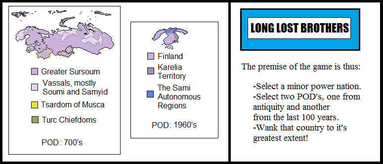 So for the first map the POD is a slightly slower expansion of the Swedish vikings into in northern Baltic, followed by a heavier flow, including attempted settlement in southern Finland. This will lead to the Finnish tribes adopting many of their technological traits including earlier adoption of iron working, farming techniques, ship building, and a little cultural diffusion from the Norse faith. The Finns manage to eventually form a more centralized state which halts Swedish settlement, though they're forced to leave a few coastal holdings to them. The Finnish kingdom, now being called Sursoum (a shoddy translation of Great Finland, of course the extra Greater was added by a man who spoke no Finnish), Christianizes earlier than the Swedes and becomes a strong ally to Catholics of Eastern Europe when it comes to dealing with Pagan tribes and Orthodox Russians. With the Russian principalities either conquered or weakened they would eventually expand east after the retreat of the Turcish hordes, absorbing other Finno-Urgic peoples, who they treat about as well as the Russians treated their fellow Slavs. By the 21st century the Suomi are a dominant power in Northern Europe and Central Asia and leading providers in oil and natural gas, and also in Herring, Reindeer, and children's trips to visit Saint Kaarlo, the patron saint of the Suomi, gift giving, and massacring Turcish hordes in the name of Jesus. This worlds version of Christmas is way more badass than our own, but Muslims like it not. ***** For my second map the POD was in the winter of 1968, when a US plane was shot down by Soviet forces along the Norwegian-Finnish-Russian border. The pilot survived, but unfortunately managed to crash land in the thick forests on the Finnish side of the border where the freezing cold prevented him from escaping until he was captured by the Finnish army. Unfortunately, in events that would lead to a pretty good action movie ITTL, Spetznaz had already been dispatched to attempt to acquire the pilots flight footage. This eventually ended up with a 2 hour shoot out and the wounding of two Russian soldiers and the death of one of their Finnish counterparts before a hasty retreat was beat back towards Rodina Mat. But the damage was done, Finland's neutrality had been broken and the Soviets were in some volcanically hot shit for violating it. Fortunately things were eventually wrapped up with the commander who had originally ordered the team to cross the border being sent to a Gulag. Skip forward 20 years to the early 90's and the USSR, which has been struggling manfully against an impossible system for so long has finally collapsed under its own weight. The emergency Premier has pulled back troops from Eastern Europe to attempt to crush the nationalist rebels in the Union. Despite Finnish speakers being a minority in the area known as Karelia even the Russian speakers have acknowledged that they're likely to do far better under democratic Finland then under whatever train wreck the Motherland is heading for, and after a few months of fighting and a suspiciously rapid referendum, the "Karelian territories" are annexed from the shaky Eurasian Federation to the Republic of Finland. Though it doesn't stop there, since with the annexation of Karelia the Finnish Sami population has increased significantly , leading to some calls that they be granted a greater autonomy from their Finnic cousins. Wanting to show the Russians how it's done the Finns give them one better, essentially recognizing the Sami as an autonomous Republic with their own Prime Minister as of 2006 (though they call him a Chancellor in English so as not to mix things up). This is followed as of 2013 with the Swede's granting their larger Sami population a similar level of autonomy, though there had been calls for a long time for them to simply join the Finnish autonomous nation. The Russian Sami in the Kola peninsula had been de jure part of Finland for years before that. The Norwegians are keeping a nervous eye on their own Sami population, ignoring that they're really too small to do much even if they did care about what their cousins were up too. 2) Scotland 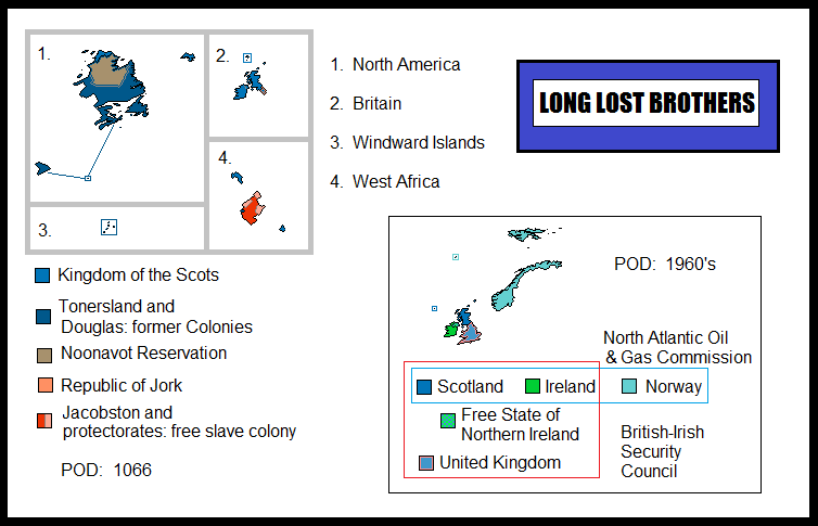 The first POD for the first map is taken during the "Harrying of the North" by William I of England, it was essentially a policy of burning out all the Saxon lords left in the north of England after the near total stripping of Saxon titles in the south by the Norman conquerors. In OTL it was a resounding success, as in the Saxon nobles and last traces of Saxon resistance to Norman rule were crushed and destroyed. ITTL however William (remembered in this world as more of a bastard than a conqueror) died unceremoniously early, a minor head wound sustained at Hastings began to have an effect on him in later years leading to some instability, by the time he died in 1069 he had been suffering from nightmares and had attempted to beat a courtier to death with a gauntlet. The Northern earls attempted to rebel with the assistance of their Danish allies, and even tried to encourage the Scots who were sheltering Edgar the Atheling, a strong claimant to the English throne, to join in driving off the Normans. The Normans were never able to fully cement their control over the North, which much like their later conquests in Wales only ever held it under great financial stress and threat of rebellion. Meanwhile the royal link established between the house of Dunkeld and Godwin which would endure for another 200 years would encourage a deal of solidarity between the northern Saxons and their Scottish cousins. Scotland ITTL does have a strong English genetic and cultural influence in their southern marches, however that link is more Anglo-Norse than Norman as in our world. A number of Scottish nobles would claim descent from English folk heroes in later centuries when they marched south to assist their cousins in insurrection. Border reavers focused their attacks on Norman noblemen and their retainers, leading to them becoming folk heroes in their own rights. The Scottish conquest/union with Ireland initially came about due to a pretender to the throne allying with the Irish High King (a more unified title in this world, the Norman knights they invited over did not have the backing to outright conquer the place). The Scots were less culturally oppressive than the English due to a the continued relevance of Gaelic in Scone, viewing the Irish more as uncivilized clansmen rather than a barbarous native population, however their attempts to bring the traditionally warring tribes under the rule of the king ended up getting nearly as violent as the English attempts did. A form of divide and rule eventually worked until the 1600's when the island kingdom was dragged screaming out of the Dark Ages. The Irish are commonly referred to as "West Scots" by their mainland brethren, they really don't like it. Scottish colonization of *Canada was only interrupted by the Portuguese, who in this world discovered the Saint Lawrence river. After a few skirmishes the Scots swore that they would not settle along the river, thus forcing their efforts into *Nova Scotia and *Labrador. However they would eventually run afoul of the Nunavut, or as they call them "Nooners", which is considered about as racist as calling a Native American a Redskin. The Scots being Scots do not care and instead think that the Nooners need to thaw their knickers out and cheer the fuck up. Jacobston has a pretty interesting history. The Scots had never established a particularly large presence in Africa as their main colonial ambitions lay in the far north along with the timber and fur trade, therefore aside from their token Caribbean colony and Douglas (which was originally a penal colony, was sold to the Dutch, and then asked to rejoin Scotland when they violently seceded 60 years later) the Scots had no real use for slaves and found themselves making the practice illegal almost a generation before the other European powers. Thus they soon found a problem with escaped slaves trying to flee to their American colonies. Unsure what to do with them the colonial authorities decided that these people may actually be useful in clearing out the disease infested jungles around Scotland's minuscule African ports. After this was done the slaves kept arriving, asking to be sent to Africa to work in ports and trading towns that had already been improved far beyond their original scope. With some quick thinking a royal commission decided that who better than to lead Scotland into the heart of darkness than the people who had been born there? Or at least their grandparents had been. 70 years later and Jacobston, named after the bordering port, was declaring itself the first African "republic" (of the enlightened 18th century variety), much to the ire of many Europeans, to which the Scots whistled nonchalantly and twiddled their thumbs. By 2015 the Scots are generally seen as pretty positive in Africa and have managed to keep a hold of their trade posts as Over Seas territories. They are more or less autonomous cities of Jacobston, who are as friendly to Scone as Canada is to Britain. ***** The modern map has another 60's POD, though this one is less farcical than a Soviet invasion of Finland. The first Scottish devolution referendum managed to acquire the 40% necessary to gain their own assembly separate from Westminster. This, along with the discovery of the North Sea oil bolsters Scotland's economy as much of the rest of Britain is floundering. This, followed by the Premiership of one Maggie Thatcher (you can never escape the devil!) eventually led to Scotland cutting from the UK and trying to make it on their own. In 2015 things aren't too bad. The Troubles exploded to an even worse degree as Nationalists tried to use Scotland as an example of the need for Celtic independence from Britain, meanwhile Unionism screamed that they'd rather die than let the Union be further destroyed and that once they had scoured Ulster clean they would exact vengeance on the closet-Papists in Edinburgh! Loyalism sat down to have a think about where separation from Scotland left them, and eventually decided that they could make the Scottish PM love them the same way they made the British love them, by blowing things up! Thatcher tried to keep the ball rolling as much as she could, but the Scots soon found that Glasgow was becoming a major entry point to Ulster by anyone looking to make a profit in death. Together with the Irish Republic they were able to garner enough international pressure to get the British to bring the UN in. It would take a decade or two of political wrangling and more than a few hundred bodies, but it was eventually decided that Northern Ireland would become a joint mandate between the Republic of Ireland, the Kingdom of Scotland, and the United Kingdom (the English refused to change the name, Wales is still angry about it), maintaining links between all three nations, occupied by their security forces, and under UN guidance. There's no one really happy with the situation, but nearly all the bombers and gunmen are in jail, in hiding, or in some other country, so it maintains the piece. Scotland has found it difficult to join the EC, and later the EU, Britain continued vetoing the initial moves, followed later by Spain who believed that the Scots would encourage their own separatists. However they soon found an ally in Norway, another oil rich northern nation which had prickly relations with the EU. Their united dickery over supply to western Europe (we want to fish god damnit!) would eventually lead to them founding their own minor economic union in 1993. Ireland would later join in 2011 after the discovery of substantial oil and gas reserves off the west, south and east coast; following a series of financial disagreements with the European Central Bank and particularly the German and French governments. Currently Scotland is the largest power of the NAOGC and de facto head of the movement, though the Irish are attempting to gain more influence thanks to their growing fuel supplies. Denmark, Iceland, the Netherlands, and even Canada have also considered joining. |
|
|
|
Post by zalezsky on Jan 27, 2016 10:52:00 GMT
Prelude to the Russo-Turkish War of 1877 Requested by Herrco  |
|
|
|
Post by Krall on Jan 27, 2016 11:26:19 GMT
Prelude to the Russo-Turkish War of 1877
Requested by Herrco Nice! Rather lacking in details, but nice. |
|
|
|
Post by fluttersky on Jan 29, 2016 3:55:27 GMT
My entry for the latest Map of the Fortnight (#130) X-posted from MotF thread. In 1936, a small parcel of land by the Ural River was separated from the Russian SSR, and handed to Roma people, in accordance with Stalin's policy for ethnic minorities to have a homeland. The Roma ASSR existed throughout the lifetime of the Soviet Union, and became the independent State of Romia in 1994. Romia is a poor nation; it is also very small and densely-populated relative to other countries in this region. Its economy is primarily agricultural; nevertheless, it is dependent on Russia for food subsidies. Population: 642,450. 85% Roma, 11% Russian, 1% Kazakh, 3% Other. Area: approx. 10,000 km^2  |
|
|
|
Post by ToixStory on Jan 29, 2016 4:03:07 GMT
A collab made with AshleeNova of AH.com. Full size here.*** Taking advantage of the Muscovites unfortunate decision to fight the Mongols, the Nordic Empire, at the time the Kalmar Union, took the opportunity to expand into northern Europe as the Russian statelets fought amongst themselves and Mongolian subjugation. Under the first Emperor Olav, the Nordics took great strides in their eastward expansion, signing treaties with the native tribes of autonomy and cooperation in order to provide a Nordic led front against Mongol raiders. As time went on the Nordic Empire expanded into Germany and the Baltic coast, winning several wars against the Hansa and the ever shrinking Holy Roman Empire while handing the Teutonic Order several crushing defeats after they attempted to seize parts of the Empires Pomeranian Territory. Their Polish allies were key to victory in several of these conflicts, and the two nations have forged a strong and mutually beneficial alliance, dividing the Russian states into their own spheres of influence. In modern day the alliance is strong, with a Germany Confederacy acting as a the buffer and occasionally battlefield against the Valois Union of France and Spain, it has stood the test of time and battle, allowing the Nordics to hold their sway over the continent and secure the eastern frontier against the ever disintegrating White Khanate.  |
|
|
|
Post by Krall on Jan 29, 2016 15:32:05 GMT
A collab made with AshleeNova of AH.com. Full size here.*** Taking advantage of the Muscovites unfortunate decision to fight the Mongols, the Nordic Empire, at the time the Kalmar Union, took the opportunity to expand into northern Europe as the Russian statelets fought amongst themselves and Mongolian subjugation. Under the first Emperor Olav, the Nordics took great strides in their eastward expansion, signing treaties with the native tribes of autonomy and cooperation in order to provide a Nordic led front against Mongol raiders. As time went on the Nordic Empire expanded into Germany and the Baltic coast, winning several wars against the Hansa and the ever shrinking Holy Roman Empire while handing the Teutonic Order several crushing defeats after they attempted to seize parts of the Empires Pomeranian Territory. Their Polish allies were key to victory in several of these conflicts, and the two nations have forged a strong and mutually beneficial alliance, dividing the Russian states into their own spheres of influence. In modern day the alliance is strong, with a Germany Confederacy acting as a the buffer and occasionally battlefield against the Valois Union of France and Spain, it has stood the test of time and battle, allowing the Nordics to hold their sway over the continent and secure the eastern frontier against the ever disintegrating White Khanate. Nice! Looks a bit flat, but I love the little indsutry map symbols. Whenabouts is this map supposed to be set? |
|
|
|
Post by ToixStory on Jan 29, 2016 17:02:51 GMT
A collab made with AshleeNova of AH.com. Full size here.*** Taking advantage of the Muscovites unfortunate decision to fight the Mongols, the Nordic Empire, at the time the Kalmar Union, took the opportunity to expand into northern Europe as the Russian statelets fought amongst themselves and Mongolian subjugation. Under the first Emperor Olav, the Nordics took great strides in their eastward expansion, signing treaties with the native tribes of autonomy and cooperation in order to provide a Nordic led front against Mongol raiders. As time went on the Nordic Empire expanded into Germany and the Baltic coast, winning several wars against the Hansa and the ever shrinking Holy Roman Empire while handing the Teutonic Order several crushing defeats after they attempted to seize parts of the Empires Pomeranian Territory. Their Polish allies were key to victory in several of these conflicts, and the two nations have forged a strong and mutually beneficial alliance, dividing the Russian states into their own spheres of influence. In modern day the alliance is strong, with a Germany Confederacy acting as a the buffer and occasionally battlefield against the Valois Union of France and Spain, it has stood the test of time and battle, allowing the Nordics to hold their sway over the continent and secure the eastern frontier against the ever disintegrating White Khanate. Nice! Looks a bit flat, but I love the little indsutry map symbols. Whenabouts is this map supposed to be set? Flat how? And as mentioned in one of the text boxes, it's around 1920 ITTL. |
|
|
|
Post by Krall on Jan 29, 2016 19:48:31 GMT
Flat how? And as mentioned in one of the text boxes, it's around 1920 ITTL. I'm not quite sure how to describe it, but it feels like nothing stands out in the map itself - like the land and the sea look like they're on the same plane, rather than the land being "above" the sea, if that makes sense. Also, do you want this MotF entry to be considered an entry from both you and AshleeNova? |
|
|
|
Post by ToixStory on Jan 29, 2016 20:42:29 GMT
Flat how? And as mentioned in one of the text boxes, it's around 1920 ITTL. I'm not quite sure how to describe it, but it feels like nothing stands out in the map itself - like the land and the sea look like they're on the same plane, rather than the land being "above" the sea, if that makes sense. Also, do you want this MotF entry to be considered an entry from both you and AshleeNova? Fair enough, and sure, it's her world and background. |
|
|
|
Post by Krall on Jan 29, 2016 20:47:03 GMT
Fair enough, and sure, it's her world and background. Okay, I'll accredit it to both of you in the voting thread. |
|
|
|
Post by lordroel on Jan 29, 2016 20:53:21 GMT
I suppose I shall re-post my most recent map on here
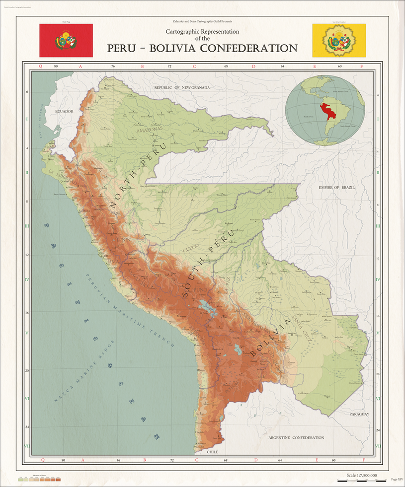 Map of the short lived Peru-Bolivia Confederation (1836–1839) For more information: Peru-Bolivia Confederation 3 States: ------------------------- North Peru (Capital: Lima) South Peru (Capital: Tacna) Bolivia (Capital: La Paz) If that would be posted on my forum you would be awarded the Grand Order of the master Map maker, and i do not joke about that. |
|