|
|
Post by zalezsky on Jan 30, 2016 10:00:42 GMT
I suppose I shall re-post my most recent map on here 
Map of the short lived Peru-Bolivia Confederation (1836–1839)
For more information: Peru-Bolivia Confederation
3 States:
-------------------------
North Peru (Capital: Lima)
South Peru (Capital: Tacna)
Bolivia (Capital: La Paz)
If that would be posted on my forum you would be awarded the Grand Order of the master Map maker, and i do not joke about that. Which forum is that? And thank you that strokes my ego just right  |
|
|
|
Post by lordroel on Jan 30, 2016 11:49:05 GMT
If that would be posted on my forum you would be awarded the Grand Order of the master Map maker, and i do not joke about that. Which forum is that? And thank you that strokes my ego just right The alternate timeline forum, link can be found at my signature. |
|
|
|
Post by zalezsky on Jan 30, 2016 14:08:00 GMT
Map of the Battle of Verdun 1916: World War One 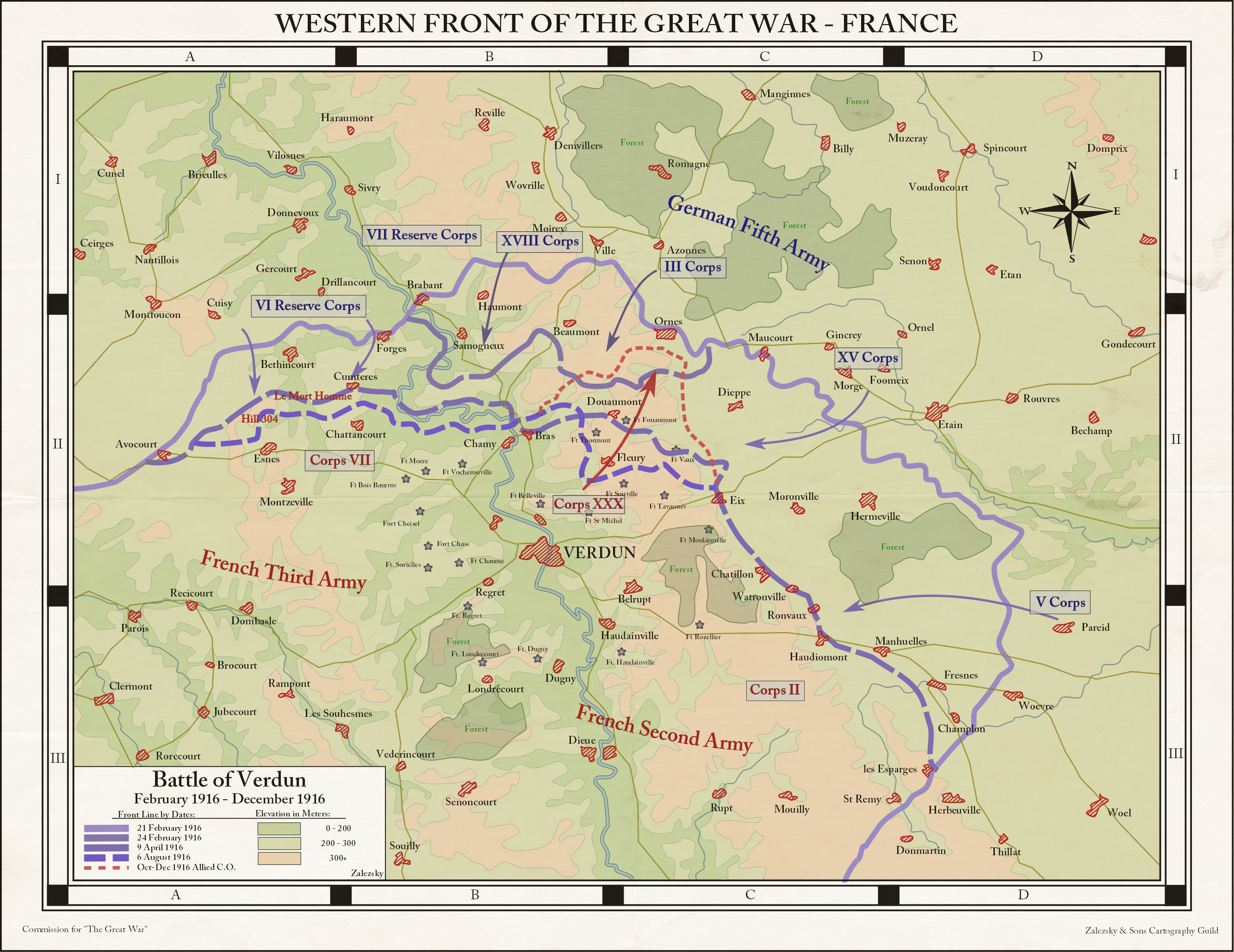 |
|
|
|
Post by Krall on Jan 30, 2016 16:12:18 GMT
Map of the Battle of Verdun 1916: World War One Looks nice - I assume this is all OTL? |
|
|
|
Post by Krall on Jan 31, 2016 22:40:02 GMT
Crossposting from the MotF contest: The Seven Years War goes differently, and France retains its holdings in North America. The threat of French invasion averts the American Revolution, but revolutions break out in Europe even without the American one for inspiration. Soon these revolutions spread to their colonies, and Spain's American colonies claim their independence. Chile notably manages to stabilise early, and is able to resolve border conflicts with its neighbours to its benefit. Without the USA democratic and stable Chile becomes something of an immigration magnet in its own right. The growing population sparks an increased demand for food, and thus mechanisation of agriculture begins alongside the quest for guano for use as fertiliser. This demand for guano leads Chile to make its first forays into the Pacific, claiming uninhabited islands at first, but soon using its local naval superiority to place protectorates over Polynesian countries outside of Europe's grasp. Chile's population grows, as does its agricultural and industrial outputs. The republic reaches its height after they and Mexico join forces to defeat Spain, leaving Chile with most of the former Spanish East Indies. This will be the height of Chile's empire, though, for as the 20th century begins it is increasingly eclipsed by its friend and brother Mexico, and soon there will be war in the family once again. 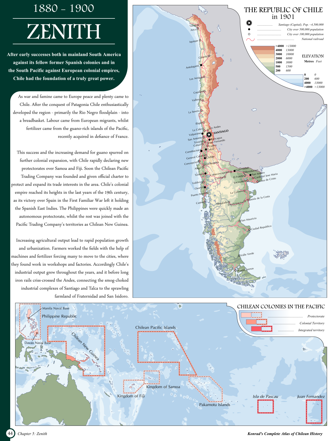 DeviantArt link DeviantArt link |
|
|
|
Post by zalezsky on Feb 1, 2016 5:09:05 GMT
Krall do more maps in general you're so amazing at them!  |
|
|
|
Post by huojin on Feb 1, 2016 21:00:15 GMT
That's a seriously cool map, Krall, I dig it.
|
|
|
|
Post by bytor on Feb 2, 2016 0:52:32 GMT
Here's two of the maps that I have created for a timeline I am working on. In 1812, Viscount Castlereagh is passed over for the leadership of the House of Commons and it is instead given to Charles Bathurst (and later George Canning). This frees Castlereagh having to support Lord Sidmouth's Six Acts in order to retain his position as Foreign Secretary, and instead of slowly withdrawing after the Aix-la-Chapelle Congress, Castlereagh and the United Kingdom maintain a strong presence in the Concert of Europe. Instead of committing suicide in 1822 like in OTL, he eventually becomes Prime Minister. The first is North America in 1849 where the first really significant changes are seen from OTL with the survival of the Republic of Texas after securing loans from France and trading agreements across Europe, and the changes that cause to the USA and Mexico.  I need to update Columbia and New Caledonia as after I finished this map I found better, more complete information as to the actual extent of those two territories. Next is Europe, also in 1849. The most significant change here, after 37 years of an activist Britain forging a Concert of Europe that prevents the Five Great Powers from intervening in most place where they otherwise would have, is the fracturing of Spain after the Progresista Liberal coalition from the rebellion of 1822 falls apart and France is not allowed to invade. However, there are also a few small republics that in OTL were crushed by Austria or Prussia. 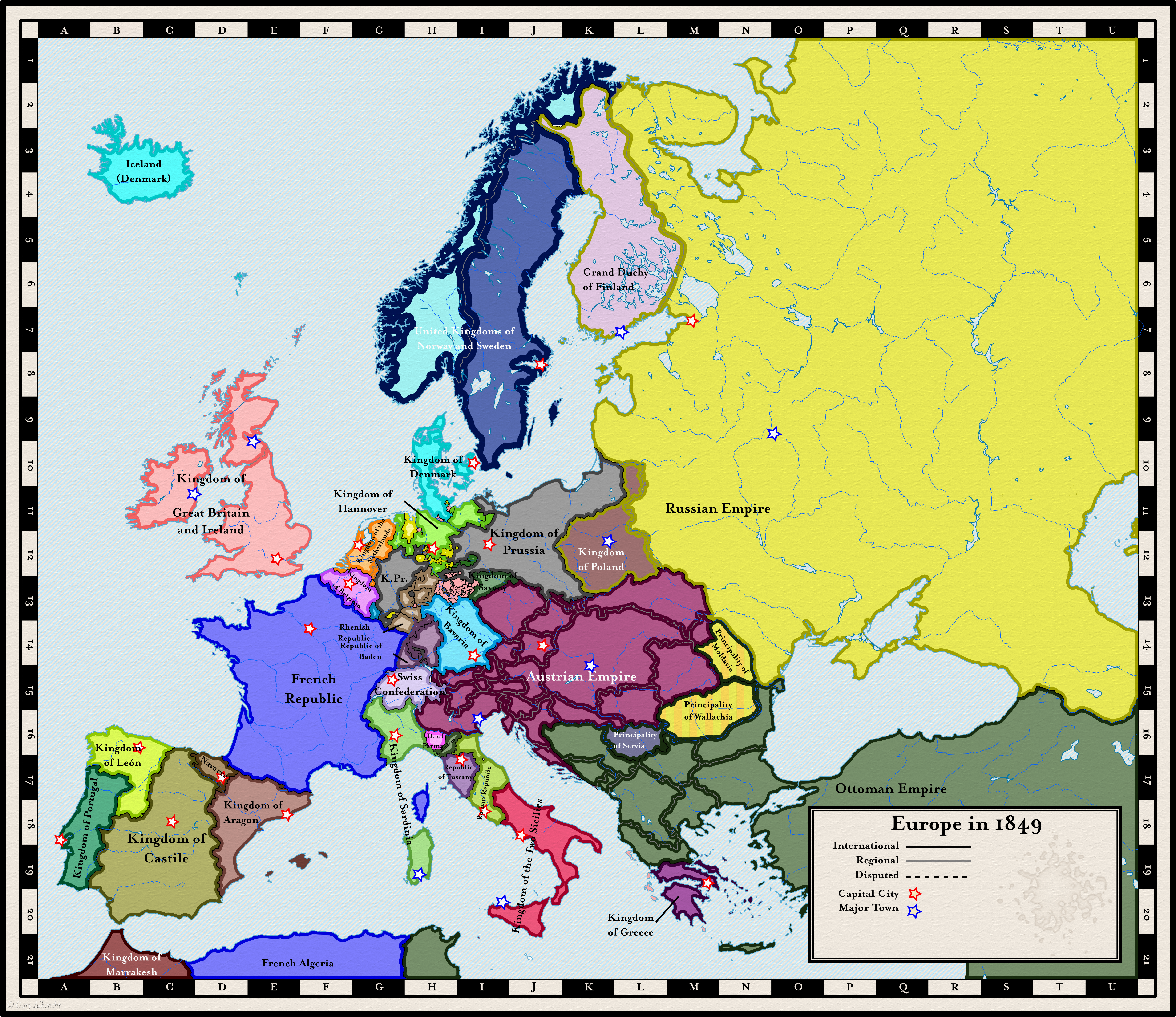 |
|
|
|
Post by bytor on Feb 2, 2016 1:06:26 GMT
I suppose I shall re-post my most recent map on here
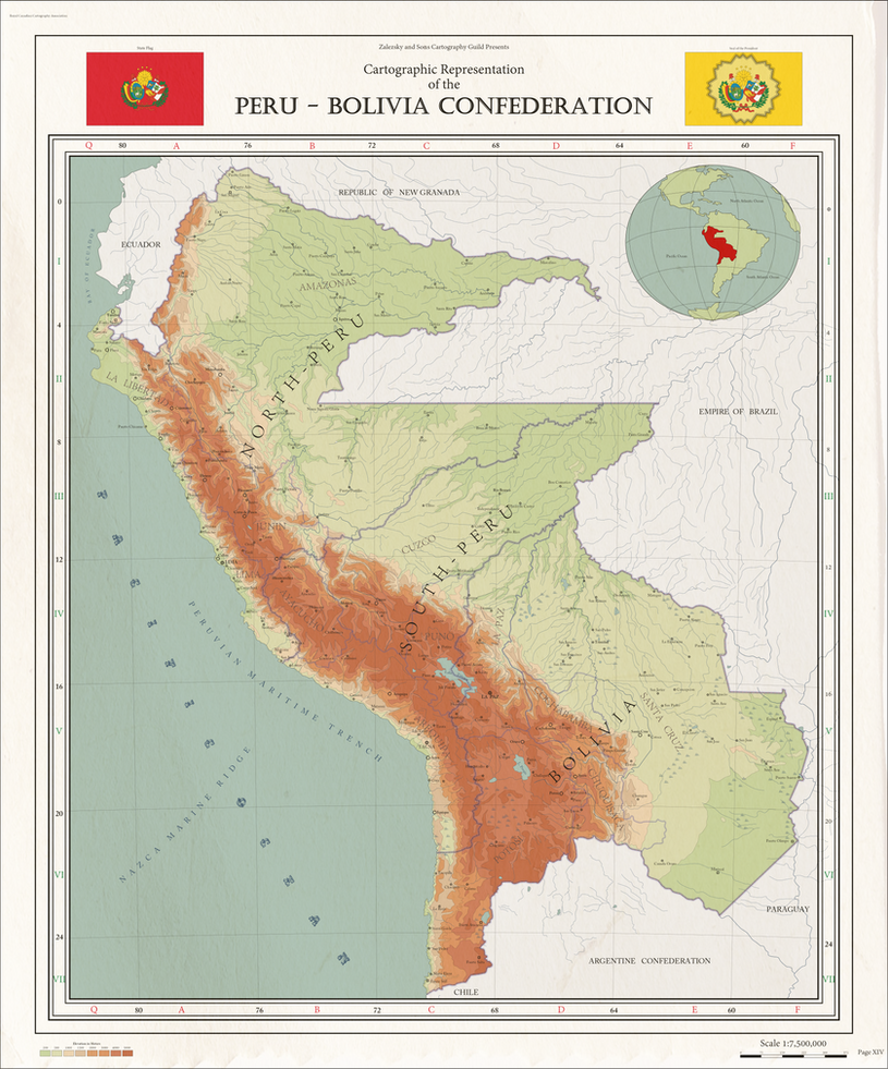 Map of the short lived Peru-Bolivia Confederation (1836–1839) For more information: Peru-Bolivia Confederation 3 States: ------------------------- North Peru (Capital: Lima) South Peru (Capital: Tacna) Bolivia (Capital: La Paz) When I grow up, I want to be like you and ToixStory. :-) |
|
|
|
Post by Krall on Feb 2, 2016 10:03:12 GMT
Krall do more maps in general you're so amazing at them! That's a seriously cool map, Krall, I dig it. Thanks guys! I feel really good about how it came out - it took a fair bit of work but I'm glad to have proven to myself that I can still make good maps in a reasonable amount of time.  Hopefully I can keep making stuff now I know I still can. |
|
|
|
Post by lordroel on Feb 2, 2016 14:57:38 GMT
Crossposting from the MotF contest: The Seven Years War goes differently, and France retains its holdings in North America. The threat of French invasion averts the American Revolution, but revolutions break out in Europe even without the American one for inspiration. Soon these revolutions spread to their colonies, and Spain's American colonies claim their independence. Chile notably manages to stabilise early, and is able to resolve border conflicts with its neighbours to its benefit. Without the USA democratic and stable Chile becomes something of an immigration magnet in its own right. The growing population sparks an increased demand for food, and thus mechanisation of agriculture begins alongside the quest for guano for use as fertiliser. This demand for guano leads Chile to make its first forays into the Pacific, claiming uninhabited islands at first, but soon using its local naval superiority to place protectorates over Polynesian countries outside of Europe's grasp. Chile's population grows, as does its agricultural and industrial outputs. The republic reaches its height after they and Mexico join forces to defeat Spain, leaving Chile with most of the former Spanish East Indies. This will be the height of Chile's empire, though, for as the 20th century begins it is increasingly eclipsed by its friend and brother Mexico, and soon there will be war in the family once again. This would also be awarded a Grand Order of the master Map maker if you had posted on my forum, you are amazing with what you have created, i can only dream of it. |
|
|
|
Post by Krall on Feb 2, 2016 20:14:11 GMT
This would also be awarded a Grand Order of the master Map maker if you had posted on my forum, you are amazing with what you have created, i can only dream of it. Ah, thanks! I'll try to pop over and post it on there soon. |
|
|
|
Post by zalezsky on Feb 4, 2016 12:59:06 GMT
I suppose I shall re-post my most recent map on here
Map of the short lived Peru-Bolivia Confederation (1836–1839)
For more information: Peru-Bolivia Confederation
3 States:
-------------------------
North Peru (Capital: Lima)
South Peru (Capital: Tacna)
Bolivia (Capital: La Paz)
When I grow up, I want to be like you and ToixStory. :-) Thanks! you maps are pretty good quality as well! |
|
|
|
Post by lordroel on Feb 4, 2016 15:33:02 GMT
This would also be awarded a Grand Order of the master Map maker if you had posted on my forum, you are amazing with what you have created, i can only dream of it. Ah, thanks! I'll try to pop over and post it on there soon. I hereby inform you that you are the second person who has received the Grand Order of the master Map maker for creating a map that stands above many on my forum, but i think i need to create a new Grand Order for maps with text but do not yet now how to name it. |
|
|
|
Post by Krall on Feb 4, 2016 16:00:35 GMT
I hereby inform you that you are the second person who has received the Grand Order of the master Map maker for creating a map that stands above many on my forum, but i think i need to create a new Grand Order for maps with text but do not yet now how to name it. Thanks! Are maps with text and maps without text really different categories that need different awards? |
|
|
|
Post by lordroel on Feb 4, 2016 16:04:32 GMT
I hereby inform you that you are the second person who has received the Grand Order of the master Map maker for creating a map that stands above many on my forum, but i think i need to create a new Grand Order for maps with text but do not yet now how to name it. Thanks! Are maps with text and maps without text really different categories that need different awards? That is the thing that bugs me, if you simply create a map, ore create a map with text expanding the map, what you created with you Chile map, is more that just a map, it is a look on what that universe is about. |
|
|
|
Post by Krall on Feb 4, 2016 18:08:09 GMT
That is the thing that bugs me, if you simply create a map, ore create a map with text expanding the map, what you created with you Chile map, is more that just a map, it is a look on what that universe is about. I'm afraid I don't understand what you mean - I don't see how my Chile map is in a different major category to any other map. |
|
|
|
Post by lordroel on Feb 4, 2016 18:12:48 GMT
That is the thing that bugs me, if you simply create a map, ore create a map with text expanding the map, what you created with you Chile map, is more that just a map, it is a look on what that universe is about. I'm afraid I don't understand what you mean - I don't see how my Chile map is in a different major category to any other map. Looking at it with more clarity i understand your point. |
|
|
|
Post by Mooncat on Feb 8, 2016 15:21:38 GMT
Can I request something? I'd like if someone could create an editable electoral map for the 70 states featured in the Union of American Socialist Republics. Kudos i.imgur.com/jEW1zyv.png |
|
|
|
Post by lordroel on Feb 8, 2016 15:41:39 GMT
Can I request something? I'd like if someone could create an editable electoral map for the 70 states featured in the Union of American Socialist Republics. Kudos i.imgur.com/jEW1zyv.pngWow that is a big map. |
|


